Photographic explorations centered around Upstate South Carolina.
Taking the upper path to Upper Grassy Falls
Get link
Facebook
X
Pinterest
Email
Other Apps
A few weeks ago, I visited Dupont State Forest in North Carolina to find a obscure waterfall, Upper Grassy Falls, on Grassy Creek. My camera failed at Wintergreen Falls forcing me to settle for cell phone photos at Upper Grassy Falls. As I arrived, three other photographers arrived from the other direction. I reasoned they arrived from a different parking area, and now that I have a working camera again, I wanted go back and take better photos of Upper Grassy Falls.
This time I went to the parking area for Grassy Dam Trail on Sky Valley Road, about 0.8 mile beyond the Guion Farm Access Area after a few steep uphill turns. This is the parking area I think those other photographers came from.
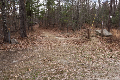
The trail begins behind a gate at the parking area. The parking area only has room for two or three cars, but I was the only there this day.
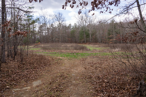
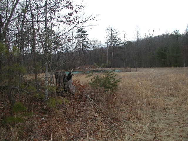
Down this trail a short distance is an open field.
An old Google Earth satellite view of this area from 1994 shows two structures, both gone.
The one on the right was a swimming pool, but is now buried. A photo from a geocache page Old and Abandoned Pool shows what the pool looked like in 2004:
That same page also notes the pool was filled with rocks. This 2005 Google Earth satellite still shows the pool, but the other structure, probably a house, is now gone:
This much more recent 2015 satellite view shows the swimming pool has been buried, but the pool's outline remains:
At the other end of the field, two trails head in different directions. I'm more interested in the waterfall, so I take the one heading to the right.
Fortunately for me, horses aren't permitted on this trail so I don't have to watch out for horse poo.
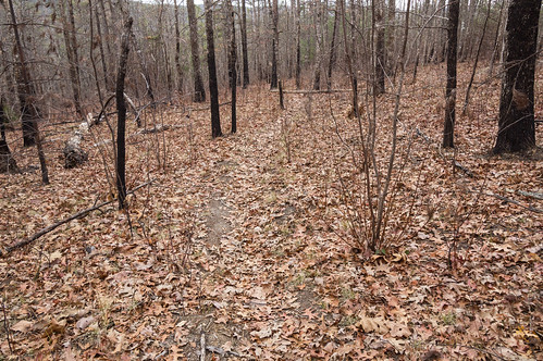
I also noticed the blackened dead tree, a sure sign of a fire sometime in the past. I spotted more evidence in other places. I wonder than happened?
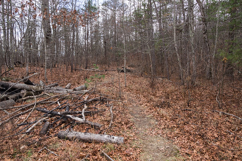
The trail wasn't marked, but it was still easy enough to follow.
The trail soon began descending toward the creek. Here the area isn't yet thick with rhododendrons:
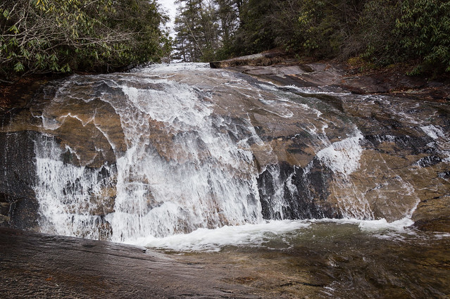
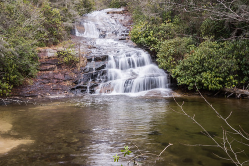
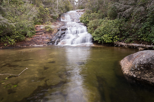
I spotted several short exit paths to the creek. I followed this path to one level below the top of the waterfall:
Then back to the trail and down to the sandy beach...
... to take photos from a few different angles:
The air grew a bit colder, and the clouds began spitting flurries and at times snow showers.
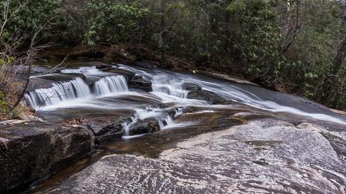
I explored my way down to Wintergreen Falls, finding little along the way of interest. I did like how this photo of the creek just above Wintergreen Falls turned out though:
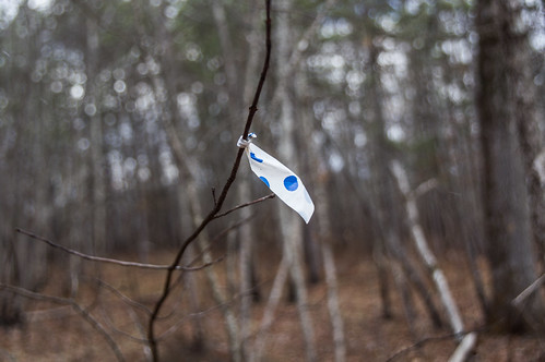
I took a few photos of Wintergreen Falls, then made my way along the trail back to the open field. Earlier I wrote the trail wasn't marked, but on the way back though, I did spot one flag along the trail.
Also the sun came back out, but even then a few tiny flurries of snow were still drifting down.
When I reached the open field, this time I took the left trail. This trail was likely an old road judging by its width and grading.
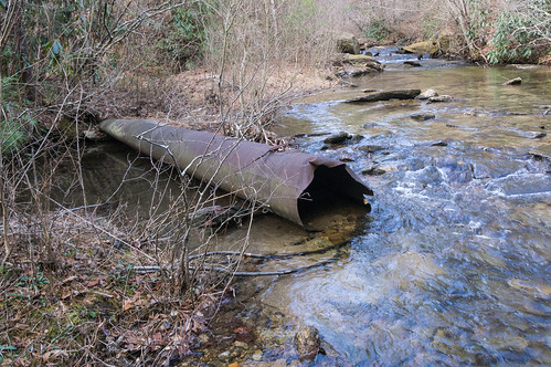
I took this trail because I was curious about the word "dam" in Grassy Dam Trail. One topo map did show a small reservoir at this trail's end, but newer ones do not. Current satellite views don't show a reservoir either. I wondered if there any ruins.
I came to a place near the creek where the road narrows and splits into two paths. I followed the left fork, but found nothing resembling a dam. At the end of the right fork I found what's left of what appears to be a rusting metal dam:
I made my way through the thicket for a better angle. I could have walked in the water, like I did during my last visit. This time, though, the air temperature is much colder so instead I slowly made my way through a thicket to get this photo:
I had wanted to stop by another part of Dupont State Forest to find a stone foundation, but that would have to wait for another time.
I made an annotated map of a portion of my GPX recording. The Google Maps version has a satellite view of the area and a KML download option.
The uMap version does not have a satellite view, but does have a GPX download option.
I wonder if DuPont conducts prescribed burns? It seems like the logical route to maintain that field as a wildlife opening, and what looks to be predominantly pine uplands would respond well to fire, resulting in that understory free of downed trees and the black trunks you saw. Pine forests are accustomed to fire, and most of the trees will survive (unless their canopy was scorched). Beautiful waterfall!
That waterfall is a beauty. I tried searching for info about wildfires, not controlled burns. I just found this article about a controlled burn in that very area: Controlled burn: Thinning DuPont's forest Thanks for the hint.
I've been to Dupont State Forest several times over the years to visit its lovely waterfalls. All but one that is, Wintergreen Falls. And then recently I heard about an undocumented waterfall in Dupont State Forest, and that increased my interest in return visit even more. But first I had to locate this undocumented waterfall! I first heard about this waterfall on the Facebook group North Carolina Waterfalls . Those posting their photos of this waterfall were coy about its exact location, and asking them for more information would have been a waste of time. To get its exact location, I would have to find out on my own. My first step was to view a few photos of the waterfall to get familiar with what it looked like. A panoramic photo of the waterfall by Christopher Cockfield and a photo by Dan Goodwin both showed a sandy beach area on the left side in front of the waterfall. (Note: I tried to embed these two photos, without success. Sorry!) I was prepared to pore over a ...
I dedicated one of my vacation days this week to visit Pinnacle Mountain Falls, a waterfall located off the Palmetto Trail on Pinnacle Mountain near Table Rock State Park in Pickens County. The trailhead is located in Table Rock State Park ($2 admission fee until the busy season, then it's $5) by what is now called Pinnacle Pavilion, formerly known as The Barn. I had the area to myself, so I felt free to give the pavilion a quick looky look. I took a peek in the window, and thought about what kind of events could be held here. Then it was on to the trailhead. I took notice of this sign. I did see plenty of small, nuisance type bees going to and from the waterfall, and a few bumble bees too, but none of them showed any interest in me. The trail is blazed yellow, and easy enough to follow. The trail crosses a dirt road... before descending toward the Table Rock Wesleyan Camp . The camp was greatly obscured by greening trees, so I couldn't capture m...
With September comes meteorological fall and cooler weather, and the area experienced just that for a few days around last Sunday. My original plan last Sunday was to spend time with my ailing 14 yr old cat, Princess, but she didn't even make it past Monday. I changed my Sunday plan to a day trip and, after consulting my ever growing to-visit list, I settled on a paddling tour of Lake Summit in Tuxedo, North Carolina. I arrived there early, at least by my standards. The place wasn't very busy when I arrived. Permits are required to access Lake Summit for powered boats and personal watercraft like jet skis, but no permit is required for kayaks. Works out fine for me! However, to get a permit you must live in the Green River Fire District. The website of the homeowner's association has those details. The gate for the boat ramp was closed at the time, forcing me to walk through the pedestrian access with my inflatable kayak. I launched and headed for my first plann...


I wonder if DuPont conducts prescribed burns? It seems like the logical route to maintain that field as a wildlife opening, and what looks to be predominantly pine uplands would respond well to fire, resulting in that understory free of downed trees and the black trunks you saw. Pine forests are accustomed to fire, and most of the trees will survive (unless their canopy was scorched). Beautiful waterfall!
ReplyDeleteThat waterfall is a beauty. I tried searching for info about wildfires, not controlled burns. I just found this article about a controlled burn in that very area:
DeleteControlled burn: Thinning DuPont's forest
Thanks for the hint.