January 2020 Hikes
My goodness, another month has come and is almost gone! Time for a report on my hikes during January 2020. I went on five hikes this month. I had more planned, but rain forced some hikes to be canceled or rescheduled.
 High Falls was throwing off so much spray, I had trouble keeping my lens dry!
 The sun was at a perfect angle to backlight the waterfall. A few clouds would have been nice.
 Fortunately, I'd find better conditions at Triple Falls. The water here was also up, but the clouds moved in helping to even out the light.

 I'm not much on black and white photography, but I also liked how the black and white version turned out!
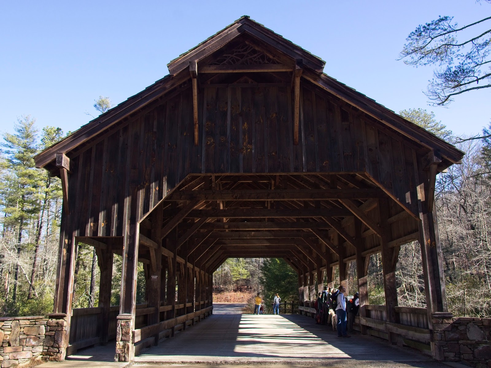
We made it as far as High Falls Bridge...
 ...before turning around to hike back to the parking area. I liked the organizer and the hikers. I'd definitely like to hike with these folks again sometime.
My photos from this trip are in the album Dupont State Forest - Jan 2020.
My goal was hike the Jones Gap Trail out to Dargans Cascades and back if time allows. If not, then just hike to Toll Road Falls and back. I paused at a bridge over the Middle Saluda River to take a photo from a viewpoint familiar to those who hike here often.
 Jones Gap Trail is rather rocky, and unfortunately I brought my thin pair of sandals. My feet were rather bruised afterwards. This is one of the few areas on the trail that wasn't quite so rocky.
 Just before the junction with Rainbow Falls Trail, I found this raccoon:
 I thought at first it was dead, but when I passed it by it managed to maneuver around to face me. That is was out this time of day was enough to tell me something was very wrong. The poor raccoon was twitching and couldn't seem to get up. I didn't see any signs the raccoon was injured (no blood, no bite wounds). I decided that I'd have to postpone my hike for a bit and go back to the visitors center to find the park rangers.
I found three park rangers (two men and one woman) about to leave to go do something else when I came upon them. I told them what I found and where and I headed back to the spot. They followed behind bringing a tarp and some gloves. They made remarks about me wearing sandals. It's hard to take offense when everyone else makes comments too, ha! I was tempted to jab back by calling one of the rangers "Jon Snow" because he resembled the Game of Thrones character, but I decided he probably got called that a lot already so I said nothing.
When I reached the spot with the rangers, the raccoon hadn't moved and now seemed completely paralyzed. It still twitched though. One tried to grab it by the scruff of the neck, but there wasn't enough for him to grab. The other fellow tried and eventually succeeded in lifting the raccoon by the scruff and placing it in the tarp.
The three rangers were very nice and I thank them for helping out. I have no doubt the poor raccoon was soon put down. They speculated the animal had distemper, and given the symptoms I observed they're probably right.
I did get the woman's name (starts with an 'M') but not the names of the two guys. I've had an epidemic of getting names wrong lately, so I won't thank her by name, but perhaps someday her and the two guys will be made aware I thanked them.
I left the rangers to handle the situation as they saw fit and headed on to Jones Gap Falls. With the ever present rains, Jones Gap Falls was flowing nicely this day. I found some angles that I thought would make for a good shot.

 I took a few more from other angles, but the two angles above are the ones I liked the best.
Ben's Sluice is on the way to Toll Road Falls. I stopped by to take a few photos. Getting a good angle is tough unless you're willing to wade into waist high water. I wasn't willing in this cool weather, so I had to settle for this one:
 I made it to the bridge constructed as an Eagle Scout project.
 Toll Road Falls is within sight of the bridge. Unfortunately, this waterfall is just not photogenic.
 Just upstream, though, is a much more photogenic waterfall, Upper Toll Road Falls. I didn't have time to find a way to the base, so a photo obscured by rhododendrons will have to do until I can try again.

My photos from this trip are in the album Jones Gap State Park - Jan 2020.
 There's not much in the way of greenery this time of year. I'm sure in the spring Looking Glass Rock will look much more photogenic.
A side trail off Cat Loop Trail took us down to Cedar Rock Falls. The mud near the bottom was black and gooey. Get this photograph was worth it though!
 If it weren't so cold, I would have moved over a few feet to get a clearer shot of the waterfall without the big rock in the way.
The photos from this trip are in the album Cat Gap - John Rock - Jan 2020.
 The path followed the Palmetto Trail past the Wesleyan Camp. A small memorial to someone's cherished pet can be found just before a descent on to a dirt road.
 After a creek crossing, the unblazed Falls Connector Trail follows a creek up to the waterfalls. The path becomes increasingly steep and rocky. One of my companions elected to wait while the two of us went up the rest of the way. The way up became rather slow as we had to pick our way up a path that became more and more of a rock garden than a trail.
Given how warm this winter (especially January) has been, I was surprised to see ice on the rocks...
 and on the waterfall.
 We made our way, slowly, down the path. We took so long our companion was beginning to wonder where we were (as we were told when we met up with him). On the way back, we met up with a fourth person was said she was coming, but that she'd wait until it warmed up.
The photos from this trip are in the album Lower Mill Creek Falls - Jan 2020.
First, we went to Issaqueena Falls. The official trail is only a few hundred feet long ending at a viewing platform. The view from there is from the side of the waterfall. But a steep scramble down an unofficial trail takes you to the base. Some hikers elected to stay at the viewing platform. Others chose to follow me down to the base. The view from down there is fantastic! If the sky was clear, this photo would have been even better:
 Next we hiked down the Blue Ridge Railroad Trail. Most of the trail was flat, but there were a few parts that had some ups and downs. The trail mostly follows an old railroad grade, intended to run from Anderson, SC to Knoxville, TN under construction from 1856 to 1859. Eighty percent of the grading was done, and some tunnels partially or completely finished before construction came to a halt in 1859. The only portion that entered actually service was from Anderson, SC to West Union, SC. Three tunnels were under construction through here: Stumphouse Tunnel, Middle Tunnel, and Saddle Tunnel.
Middle Tunnel is the first of the tree we encountered. This was the only tunnel completed, but one end was closed in the 1950s. This end is the open end, but a gate prevents anyone from disturbing the bat habitat inside.
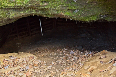 A line formed to check out the inside:
 We stopped again at the closed end, then we moved on to Saddle Tunnel.
Saddle Tunnel is at the end of the trail and beyond is private property. Saddle Tunnel was never completed, and is now mostly submerged:
 We hiked the 3 miles or so back to the parking area. After a brief rest, we headed to Stumphouse Tunnel, the most famous of the three tunnels. Stumphouse Tunnel was intended to be 5,863 feet long, but only 1,617 feet was ever completed before construction was halted in 1859. We took out our flashlights and our phones (in some cases, people's phones were their flashlights) and headed in:
 The quality of my photos is as one would expect from being in the dark with not much light:
 Afterwards, some of us gathered at a Clemson pizza restaurant to gain back some of those calories we lost out in the trail and then some.
The photo album of this trip are in Issaqueena Falls, Stumphouse Tunnel, and the Blue Ridge Railroad Trail - Jan 2020.
Dupont State Forest - High Falls and Triple Falls
The first Saturday of January I went with a great group up to Dupont State Forest. During the visit we visited High Falls and Triple Falls. High Falls was really throwing off some spray this day.


We made it as far as High Falls Bridge...
My photos from this trip are in the album Dupont State Forest - Jan 2020.
Jones Gap State Park - Jones Gap Falls and Toll Road Falls
A few days after the group hike at Dupont, I went by myself up to Jones Gap State Park. It had rained the night before, and one last band of showers was passing through when I made it to the parking area.My goal was hike the Jones Gap Trail out to Dargans Cascades and back if time allows. If not, then just hike to Toll Road Falls and back. I paused at a bridge over the Middle Saluda River to take a photo from a viewpoint familiar to those who hike here often.


I found three park rangers (two men and one woman) about to leave to go do something else when I came upon them. I told them what I found and where and I headed back to the spot. They followed behind bringing a tarp and some gloves. They made remarks about me wearing sandals. It's hard to take offense when everyone else makes comments too, ha! I was tempted to jab back by calling one of the rangers "Jon Snow" because he resembled the Game of Thrones character, but I decided he probably got called that a lot already so I said nothing.
When I reached the spot with the rangers, the raccoon hadn't moved and now seemed completely paralyzed. It still twitched though. One tried to grab it by the scruff of the neck, but there wasn't enough for him to grab. The other fellow tried and eventually succeeded in lifting the raccoon by the scruff and placing it in the tarp.
The three rangers were very nice and I thank them for helping out. I have no doubt the poor raccoon was soon put down. They speculated the animal had distemper, and given the symptoms I observed they're probably right.
I did get the woman's name (starts with an 'M') but not the names of the two guys. I've had an epidemic of getting names wrong lately, so I won't thank her by name, but perhaps someday her and the two guys will be made aware I thanked them.
I left the rangers to handle the situation as they saw fit and headed on to Jones Gap Falls. With the ever present rains, Jones Gap Falls was flowing nicely this day. I found some angles that I thought would make for a good shot.


Ben's Sluice is on the way to Toll Road Falls. I stopped by to take a few photos. Getting a good angle is tough unless you're willing to wade into waist high water. I wasn't willing in this cool weather, so I had to settle for this one:


Cat Loop Trail and John Rock
A few days after my solo adventure I went up to the parking area for the Pisgah Center for Wildlife Education near Brevard, NC with a meetup group. We hiked the Cat Loop Trail and the John Rock Trail. On John Rock, we found a few viewpoints of Looking Glass Rock in the distance. This viewpoint was one of the best:
A side trail off Cat Loop Trail took us down to Cedar Rock Falls. The mud near the bottom was black and gooey. Get this photograph was worth it though!

The photos from this trip are in the album Cat Gap - John Rock - Jan 2020.
Table Rock State Park - Lower Mill Creek Falls
Last Wednesday, I put together a meetup hike to Lower Mill Creek Falls (aka Pinnacle Mountain Falls) in Table Rock State Park. Three of us met at the Pinnacle Pavilion parking area where the trailhead for the hike is located.

Given how warm this winter (especially January) has been, I was surprised to see ice on the rocks...


The photos from this trip are in the album Lower Mill Creek Falls - Jan 2020.
Issaqueena Falls, Stumphouse Tunnel, and Two More Railroad Tunnels
The last and most recent hike was to Issaqueena Falls and Stumphouse Tunnel, both inside a park owned by the City of Walhalla. I led a meetup group to several areas inside the park.First, we went to Issaqueena Falls. The official trail is only a few hundred feet long ending at a viewing platform. The view from there is from the side of the waterfall. But a steep scramble down an unofficial trail takes you to the base. Some hikers elected to stay at the viewing platform. Others chose to follow me down to the base. The view from down there is fantastic! If the sky was clear, this photo would have been even better:

Middle Tunnel is the first of the tree we encountered. This was the only tunnel completed, but one end was closed in the 1950s. This end is the open end, but a gate prevents anyone from disturbing the bat habitat inside.


Saddle Tunnel is at the end of the trail and beyond is private property. Saddle Tunnel was never completed, and is now mostly submerged:


The photo album of this trip are in Issaqueena Falls, Stumphouse Tunnel, and the Blue Ridge Railroad Trail - Jan 2020.


Comments
Post a Comment