Two parks, one day: Pleasant Ridge and Wildcat Wayside
I haven't been able to get away a while, but with a few days off I decided to visit two popular parks off of S.C. Highway 11, Pleasant Ridge County Park and Wildcat Wayside State Park. I've been to Wildcat Wayside many times over the years, but I don't recall ever going to Pleasant Ridge.
Pleasant Ridge is the nearest, so I went there first. Their colorful entrance sign makes for an eye catching advertisement.
View Pleasant Ridge and Wildcat Wayside in a larger map

While walking back to the parking area after taking that photo, I read over a sign about the origins of the park.

I learned this park originally built for "Negroes" in the early 1950s during the segregation era. A September 1951 story in the The News and Courier concurs. Thankfully, such nonsense ended in the 1960s when the state parks were all integrated. Leroy L. Smith was the park's first superintendent and stayed until his death in 1979.
Three shelters are available for picnicing and other events. I happened to park near Shelter #1.

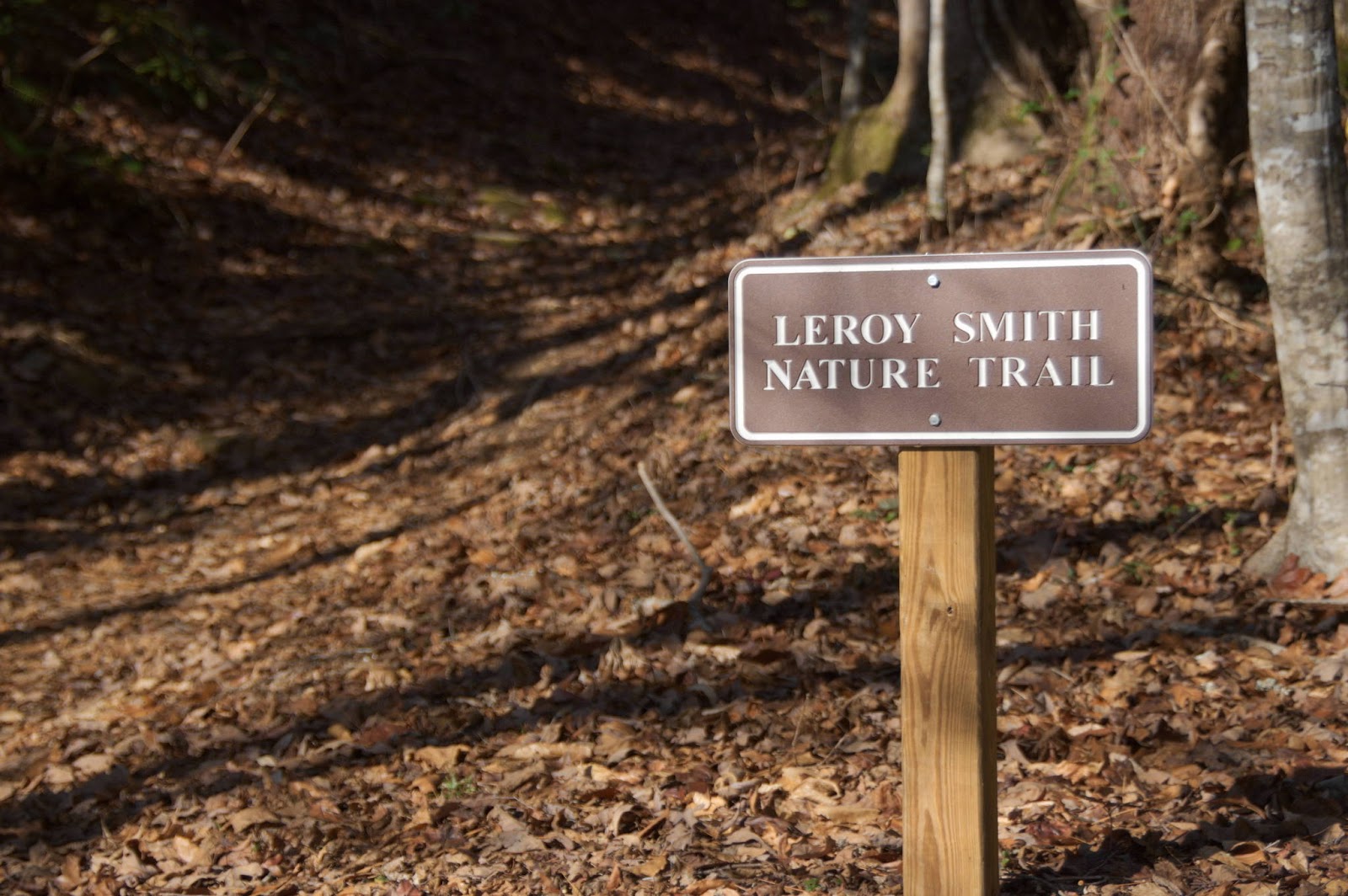
The Leroy Smith Nature Trail, named after the park's first superintendent, is the park's only trail.

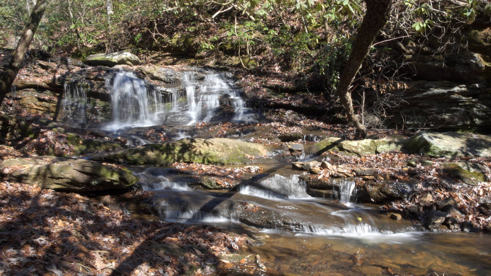
I had a choice of two trailheads, and I chose the one that paralleled the stream thinking it was the shortest way to the waterfall. I guessed correctly:

A bit further down the trail, I saw a sign marking the location of an old moonshine still.

The only evidence left of the still were rusty bands from the metal drums used to make the moonshine.

I went up these steps to check out Shelter #3 and the lake.


Behind Shelter #3 were two horseshoe pits.

I spent too much time playing horseshoes and missing the target, so I reluctantly gave up and explored the lake.

After finishing the hike, I drove through the camp area. The camp is closed for the season, and I saw only a few cars parked in the office area.


Wildcat Wayside was my second stop. Wildcat Wayside was built by the C.C.C. back in the late 1930s, known then as Greenville Wayside, then turned over to the state in the early 1940s. The most visited waterfall is Lower Wildcat Falls, or as the sign calls it, Wildcat Branch Falls. It's right by the roadside parking area, making it rather hard to miss.


Down the trail and at the top of this waterfall is a memorial to a hiker who fell from the top of Upper Wildcat Falls (located down the trail) back in September.

Middle Wildcat Falls is only a few feet down the trail.

Further down the trail are the remains of structures built by the Civilian Conservation Corps back in the late 1930s, including what may have been a picnic shelter.

Continuing on, I noticed some steps that weren't there during my last visit in 2011.

I had to go up these steps, of course. I found, as did blogger RustyBolt1, the trail followed the right bank of Wildcat branch to Upper Wildcat Falls and then linking up with the original trail.

People have died falling from the top of this waterfall over the years, the most recent fatalities were David Lewis in April 2011 and Billy Gorham in September 2012 (memorialized in the photo above). It's a risky, dangerous place to be. Please don't go there.
While walking back to the roadside, several entrances to a side trail leading to a gneiss outcrop and three more waterfalls remain deliberately obscured. These strategically placed limbs, for example:

I've been down this trail before and I wanted to see what, if anything, has changed since my last visit. The "Aztec Warrior" graffiti has faded somewhat:
Pleasant Ridge is the nearest, so I went there first. Their colorful entrance sign makes for an eye catching advertisement.
Pleasant Ridge County Park

While walking back to the parking area after taking that photo, I read over a sign about the origins of the park.

I learned this park originally built for "Negroes" in the early 1950s during the segregation era. A September 1951 story in the The News and Courier concurs. Thankfully, such nonsense ended in the 1960s when the state parks were all integrated. Leroy L. Smith was the park's first superintendent and stayed until his death in 1979.
Three shelters are available for picnicing and other events. I happened to park near Shelter #1.

The Leroy Smith Nature Trail, named after the park's first superintendent, is the park's only trail.
I had a choice of two trailheads, and I chose the one that paralleled the stream thinking it was the shortest way to the waterfall. I guessed correctly:
A bit further down the trail, I saw a sign marking the location of an old moonshine still.

The only evidence left of the still were rusty bands from the metal drums used to make the moonshine.

I went up these steps to check out Shelter #3 and the lake.


Behind Shelter #3 were two horseshoe pits.

I spent too much time playing horseshoes and missing the target, so I reluctantly gave up and explored the lake.

After finishing the hike, I drove through the camp area. The camp is closed for the season, and I saw only a few cars parked in the office area.


Wildcat Wayside State Park
View Pleasant Ridge and Wildcat Wayside in a larger map
Wildcat Wayside was my second stop. Wildcat Wayside was built by the C.C.C. back in the late 1930s, known then as Greenville Wayside, then turned over to the state in the early 1940s. The most visited waterfall is Lower Wildcat Falls, or as the sign calls it, Wildcat Branch Falls. It's right by the roadside parking area, making it rather hard to miss.


Down the trail and at the top of this waterfall is a memorial to a hiker who fell from the top of Upper Wildcat Falls (located down the trail) back in September.

Middle Wildcat Falls is only a few feet down the trail.

Further down the trail are the remains of structures built by the Civilian Conservation Corps back in the late 1930s, including what may have been a picnic shelter.
 |
| From 2011 |
And also a non-working water fountain.

Continuing on, I noticed some steps that weren't there during my last visit in 2011.

I had to go up these steps, of course. I found, as did blogger RustyBolt1, the trail followed the right bank of Wildcat branch to Upper Wildcat Falls and then linking up with the original trail.

People have died falling from the top of this waterfall over the years, the most recent fatalities were David Lewis in April 2011 and Billy Gorham in September 2012 (memorialized in the photo above). It's a risky, dangerous place to be. Please don't go there.
While walking back to the roadside, several entrances to a side trail leading to a gneiss outcrop and three more waterfalls remain deliberately obscured. These strategically placed limbs, for example:

I've been down this trail before and I wanted to see what, if anything, has changed since my last visit. The "Aztec Warrior" graffiti has faded somewhat:
 |
| 2012 |
 |
| 2011 |
... and the trash that was there in 2011 has been removed.
The remains of a campfire are still there, minus the burnt wood shown here.
On the way to the gneiss outcrop, I noticed neons ribbons marking the location of a new trail. I didn't have time to follow it this time, but I'll definitely investigate it next visit.
The trail ends at the gneiss outcrop...

...but Slickum Creek is just a short distance away with five waterfalls between the gneiss outcrop and the roadside. By this time, I had to be somewhere else, so I had to head back down the trail and back to the car. I did visit these Slickum Creek waterfalls back in 2011:
The Millennium Falls require bushwacking to visit, but Last Falls on Slickum and Sweet Thing on Slickum are easily reachable from a trail by the roadside.


This trail is a few hundred yards down the road from the Wildcat Wayside parking area just beyond the culvert over the creek. I plotted it's approximate location on the map above.
While I was disappointed I didn't have time to revisit all the waterfalls from my 2011 visit, I did like hiking the new trail and seeing evidence of yet another new trail.
Wildcat Wayside further reading
 |
| 2011 |
 |
| 2011 |
The trail ends at the gneiss outcrop...

...but Slickum Creek is just a short distance away with five waterfalls between the gneiss outcrop and the roadside. By this time, I had to be somewhere else, so I had to head back down the trail and back to the car. I did visit these Slickum Creek waterfalls back in 2011:
 |
| Upper Millennium Falls |
 |
| Middle Millennium Falls |
 |
| Lower Millennium Falls |
 |
| Sweet Thing on Slickum |
 |
| Last Falls on Slickum |


This trail is a few hundred yards down the road from the Wildcat Wayside parking area just beyond the culvert over the creek. I plotted it's approximate location on the map above.
While I was disappointed I didn't have time to revisit all the waterfalls from my 2011 visit, I did like hiking the new trail and seeing evidence of yet another new trail.
Wildcat Wayside further reading
- National Register of Historic Places nomination form for Wildcat Wayside and other CCC built state parks.
- The Civilian Conservation Corps in South Carolina 1933-1942
- South Carolina State Parks book (1940)
- 1937 deed to United States of America (vol 201, page 247)
- 1942 deed to State of South Carolina (voll 264, page 242)
- [Dec 25, 2012: Link times out] South Carolina Archives ONLINE catalog listing - an index of the original plans for Wildcat Wayside (originally Greenville Wayside) available "offline".


Comments
Post a Comment