Tracing the Swamp Rabbit Railroad
Update: Follow this link to list all entries in what became a series.
The Swamp Rabbit Trail, the successful rails-to-trail conversion, currently extends from downtown Greenville to Travelers Rest with plans to extend the trail southward to Fountain Inn. The Greenville County Recreational Department is seeking support for a project to extend the northern end of the trail up to Slater-Marietta.
The Swamp Rabbit Trail closely follows the route of the Greenville & Northern railroad, better known as the Swamp Rabbit Railroad, from downtown Greenville to just north of Travelers Rest matching where the railroad had ended since the mid-1950s. However, as late as 1921, the railroad ended at River Falls, near Jones Gap, and as late as 1933 in Marietta. This part of the railroad route isn't plotted on any modern maps, being abandoned long ago, making me interested in learning more about the route the Swamp Rabbit railroad took to from Travelers Rest to River Falls.
I read over Abandoned Railroad's section about the Swamp Rabbit, but their map was missing a segment. I researched online historic maps, satellite images, Greenville County's GIS, and some old fashioned on-the-ground field work to help produce my own map on Google Maps with the results of my own research.
Historic maps are good place to start, if you can find a map from the right time period. The SC Digital Library has a 1921 Greenville County soil map showing the route of the railroad all the way from downtown Greenville to River Falls. I already knew where the railroad route traversed between Greenville and Travelers Rest since the Swamp Rabbit Trail so closely follows the railroad right-of-way and modern maps, of course, show the trail. The soil map's rendering of the railroad's route north of Travelers Rest provided me enough information to draw a crude rendering of this part of the route on my own map.
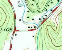
Next, I examined historical USGS quad maps of the area, the useful ones being Tigerville (1959), Cleveland (1961), and Slater (1983). These maps are free to download, but beware if you are on a slower connection the files are rather large and may take a while to download. These maps more accurately showed the railroad route and the terrain, allowing me to better match the route with modern features.
The Cleveland map has a black dashed line running from just north of Tankersley Lake up to River Falls.
The map doesn't identify what feature the black dashed line represents, but it matches up closely with the route shown on 1921 soil map.
The routes shown on the 1961 Cleveland map and the 1921 soil map closely match each other, but disagree slightly on where at River Falls the line ended. The 1921 soil map advocates a spot close to where the River Falls Fire Department is now on the west side of the Middle Saluda River.
But the 1961 Cleveland map advocates a spot near the east bank of the Middle Saluda River and the confluence of Gap Creek.
The 1961 Cleveland map is much more accurate about all other features, so I'm going with its route until shown otherwise.
When I switched Google Maps to satellite view, I can see how closely my route matched the actual route where the right-of-way is still visible. Beyond where the railroad crosses U.S. 276/S.C. 11, where the railroad has been abandoned the longest, the route becomes mostly impossible to find from the satellite view.
In Slater, Greenville County's GIS proved useful by showing in places where the right-of-way is unclaimed or can be inferred. In this snippet from the GIS, historical lines (the red dashed lines) curving toward U.S. 276 show the abandoned right-of-way.
 In another snippet from Slater, the railroad right-of-way is truly abandoned (owner unknown), running in a northeasterly direction near Cleveland Avenue Extension.
Like the satellite view, Greenville County's GIS is of little help north of U.S. 276/S.C. 11. Greenville County's Register of Deeds does have records of the the right-of-way deeds granted to the railroad under the railroad's early names Carolina, Knoxville & Western and Greenville & Knoxville, but the deeds are way too vague to be useful. The later deeds and plats I've found so far associated with the Greenville & Northern confirm what the satellite and maps show, but I did find the location of the Marietta depot from a plat and the location has been added to my map. I'm still going through the later deeds and plats to look for more buried nuggets.
Now that I've exhausted all my online resources, it's time for "ground truth". This is the map I've created and will use for reference:
I started at the northern end of the Swamp Rabbit Trail just north of Travelers Rest where the path was easy to see:
 Near Slater-Marietta Elemetary School I found some of the abandoned right-of-way is still visible:


 The abandoned railroad parallels public roads most of the way up to Echo Valley in Cleveland. In Echo Valley down to Marietta, the abandoned railroad found temporary new life during the mid-to-late 1960s as an attraction of the Echo Valley Park. Fellow adventurer Tom Taylor wrote about the brief history of theme park and his visits there in his blog post Memories of Echo Valley.
 In the Echo Valley area near the present Cleveland post office, these pillars over a small creek are the most obvious signs around of the railroad left:
 North of here, the abandoned railroad travels near several large tracts of farmland on private property until crossing McCarson Road, heading northwestward toward River Falls Road.
Just north of the intersection of River Falls Road and McCarson Road in the Middle Saluda River are some ruins (a mill?), and the ruins of a trestle:
 Nice! I looked around the other side of River Falls Road, and found a cutting in the rock where the railroad continued on northwest. I climbed up the steep embankment and found this:
 Evidently, at least one other person was here not that long ago as I found one burned campfire and another campfire ready to be lit.
The path was headed toward the electrical lines and the road, and not wanting to meet the maker of the campfire if I could help it, I went back to my car and followed the electrical lines until the lines crossed the road. I found no more signs of the abandoned railroad after my find, and it was getting dark, so I headed home.
The signs of the Swamp Rabbit railroad I did find, especially in River Falls, provided me information that helped make my map more accurate. I have the least confidence in the segment between U.S. 276/S.C. 11 and the intersection of River Falls Road and Devils Fork Road, except for the Middle Saluda River crossing on River Falls Road I verified personally.
The photos above and a few more are all in my Swamp Rabbit Railroad photo album on Google Photos. Each photo's mapped location can be viewed with the the photo details option.
If you want to know more about the history of the Swamp Rabbit railroad, I suggest purchasing Mann Batson's recent book, The Swamp Rabbit Railroad: Legacy and Legend, and if possible, buy the book from the Travelers Rest Historical Society.
Update: The next entry in the series is Tracing the Swamp Rabbit Railroad part 2, or list all entries in the series.
Update Jan 2016: Change map link to currently maintained map. Remove some map views that look wrong now with Google's updated look. Fixed link to Greenville County's GIS after Greenville County shut down their old interface in favor of the mobile friendly one.
Map sources
The Swamp Rabbit Trail, the successful rails-to-trail conversion, currently extends from downtown Greenville to Travelers Rest with plans to extend the trail southward to Fountain Inn. The Greenville County Recreational Department is seeking support for a project to extend the northern end of the trail up to Slater-Marietta.
The Swamp Rabbit Trail closely follows the route of the Greenville & Northern railroad, better known as the Swamp Rabbit Railroad, from downtown Greenville to just north of Travelers Rest matching where the railroad had ended since the mid-1950s. However, as late as 1921, the railroad ended at River Falls, near Jones Gap, and as late as 1933 in Marietta. This part of the railroad route isn't plotted on any modern maps, being abandoned long ago, making me interested in learning more about the route the Swamp Rabbit railroad took to from Travelers Rest to River Falls.
I read over Abandoned Railroad's section about the Swamp Rabbit, but their map was missing a segment. I researched online historic maps, satellite images, Greenville County's GIS, and some old fashioned on-the-ground field work to help produce my own map on Google Maps with the results of my own research.
Historic maps are good place to start, if you can find a map from the right time period. The SC Digital Library has a 1921 Greenville County soil map showing the route of the railroad all the way from downtown Greenville to River Falls. I already knew where the railroad route traversed between Greenville and Travelers Rest since the Swamp Rabbit Trail so closely follows the railroad right-of-way and modern maps, of course, show the trail. The soil map's rendering of the railroad's route north of Travelers Rest provided me enough information to draw a crude rendering of this part of the route on my own map.
.jpg) |
| 1921 map with the Greenville & Northern railroad route |
The Cleveland map has a black dashed line running from just north of Tankersley Lake up to River Falls.
 |
| 1961 USGS Cleveland quad map snippet |
The routes shown on the 1961 Cleveland map and the 1921 soil map closely match each other, but disagree slightly on where at River Falls the line ended. The 1921 soil map advocates a spot close to where the River Falls Fire Department is now on the west side of the Middle Saluda River.
 |
| 1921 map - terminus on west side of the Saluda |
But the 1961 Cleveland map advocates a spot near the east bank of the Middle Saluda River and the confluence of Gap Creek.
 |
| 1961 map - terminus on the east side of the Saluda |
The 1961 Cleveland map is much more accurate about all other features, so I'm going with its route until shown otherwise.
When I switched Google Maps to satellite view, I can see how closely my route matched the actual route where the right-of-way is still visible. Beyond where the railroad crosses U.S. 276/S.C. 11, where the railroad has been abandoned the longest, the route becomes mostly impossible to find from the satellite view.
In Slater, Greenville County's GIS proved useful by showing in places where the right-of-way is unclaimed or can be inferred. In this snippet from the GIS, historical lines (the red dashed lines) curving toward U.S. 276 show the abandoned right-of-way.
 |
| Abandoned right-of-way running SW to NE |
Now that I've exhausted all my online resources, it's time for "ground truth". This is the map I've created and will use for reference:
I started at the northern end of the Swamp Rabbit Trail just north of Travelers Rest where the path was easy to see:


Just north of the intersection of River Falls Road and McCarson Road in the Middle Saluda River are some ruins (a mill?), and the ruins of a trestle:


The path was headed toward the electrical lines and the road, and not wanting to meet the maker of the campfire if I could help it, I went back to my car and followed the electrical lines until the lines crossed the road. I found no more signs of the abandoned railroad after my find, and it was getting dark, so I headed home.
The signs of the Swamp Rabbit railroad I did find, especially in River Falls, provided me information that helped make my map more accurate. I have the least confidence in the segment between U.S. 276/S.C. 11 and the intersection of River Falls Road and Devils Fork Road, except for the Middle Saluda River crossing on River Falls Road I verified personally.
The photos above and a few more are all in my Swamp Rabbit Railroad photo album on Google Photos. Each photo's mapped location can be viewed with the the photo details option.
If you want to know more about the history of the Swamp Rabbit railroad, I suggest purchasing Mann Batson's recent book, The Swamp Rabbit Railroad: Legacy and Legend, and if possible, buy the book from the Travelers Rest Historical Society.
Update: The next entry in the series is Tracing the Swamp Rabbit Railroad part 2, or list all entries in the series.
Update Jan 2016: Change map link to currently maintained map. Remove some map views that look wrong now with Google's updated look. Fixed link to Greenville County's GIS after Greenville County shut down their old interface in favor of the mobile friendly one.
Map sources
- 1921 Greenville County soil map part of the USC Digital Library. Website
- USGS quad maps: 1959 Tigerville (10.7MB), 1961 Cleveland (12MB), 1983 Slater (10.7MB)
- GCGIS used to fine tune the Swamp Rabbit railway map. In some cases, the exact location of the right of way can be inferred from historical property lines (shown with red dashes) or from the shape of the property lines themselves.
- Google Maps satellite and terrain view.
Even more reading
- Historically Speaking: The History of the Swamp Rabbit Trail from November 17, 2010 The Travelers Rest Tribune.
- Greenville to River Falls by Abandoned Rails
- Swamp Rabbit Trail Use Agreement
- Greenville Rec District asks for public's help in trail project grant approvals
Contemporary newspaper stories
- Thomas Wilson Building Another Railroad from the March 28, 1900 The Watchman and Southron.
- The Swamp Rabbit Railway from the July 13, 1904 Keowee Courier.
- Looking Southward from the November 24, 1905 Sylvan Valley News. Hope springs eternal the railway will be extended to North Carolina and on to Knoxville.
- Swamp Rabbit Sold Again from the July 30, 1919 Keowee Courier.
- 1926 story from the Greenville News
Photos of the locomotives
- Greenville & Northern by RailPictures.net
- 1888 photo of track and locomotive at the SC Digital Library.
- 1938 photo of train
- 1977 color photo of locomotive by Frankie Grove.


Excellent post, and great research, as usual. It's fascinating what these old maps can reveal. I keep forgetting about the soil survey maps - there were several old schools located on your link to the Greenville map that I now want to explore.
ReplyDeleteWe had driven up that way just last Sunday, and I had wondered where the old track traveled beyond the Renfrew community. I have paddled/floated that section of the Saluda River, but don't remember seeing the old trestle. I may have to head back that way and look for it now.
The lengths I go to find you new blog material. ;)
ReplyDeleteVery interesting...always wondered exactly where the route was past TR. Have you perhaps explored and documented where the Pickens Railroad (Appalachian) went on its way from Pickens to Eastatoe? Some remnants remain but very difficult to trace in most areas coming out of Pickens.
ReplyDeleteI have walked the trail that ends above Twin Falls where all the twisted railroad ties are. My trip report is here: http://markemark4.blogspot.com/2012/03/town-creek-park-and-twin-falls-trail.html
DeleteThis is great. Have you documented where the Pickens RR went as it left Pickens to head to logging lands in Eastatoe?
ReplyDeleteThis fellow has walked a good bit of the Appalachian Lumber Railroad's path: http://archive.upstatetoday.com/?p=27798
DeleteMy wife owns the properly where the turn around was located at Hart Cut rd. You can still see where the tracks ran. The tracks have been removed but you can find spikes and tie downs.
ReplyDeleteThis is fascinating. Thanks for all the hard work documenting this. I have traced most of the route, but not to the level of detail that you have. I believe the Swamp Rabbit crossed the Reedy River behind the Peace Center, then ran through the Pettigru historic district and crossed the trestle by the zoo. The trestle was removed in 1991 and there are only a few traces left until the railroad bed begins again behind Willy Taco on Laurens Rd. and E. Washington.
ReplyDeleteMark, my family owns the property with the cabin on the river, just south of the intersection of River Falls Rd and Gap Creek Rd and across the river where you show 'stone ruins' and this property dates back in my family to before the railroad was ever built. These are not ruins, but a natural rock outcropping on the river. I can show you on your map where the railroad crossed the river at this point if you want to email at fcantre@msn.com and I'll reply with a screenshot.
ReplyDelete