Where was Ansel School?
Like Reid School Road, Ansel School Road also takes its name from a school that no longer exists. But unlike Reid School, the deed recording the buying of property for the school is available.
A deed recorded October 13, 1896 in deed book EEE, page 324 transfers one acre of land from S. D. Mosteller to Ansel School District "only for school purposes for educating white children" and also grants the school use of a well in the northeast end of the property. On September 26, 1919, the school district added more land to the school property by buying another acre from S. D. Mosteller.
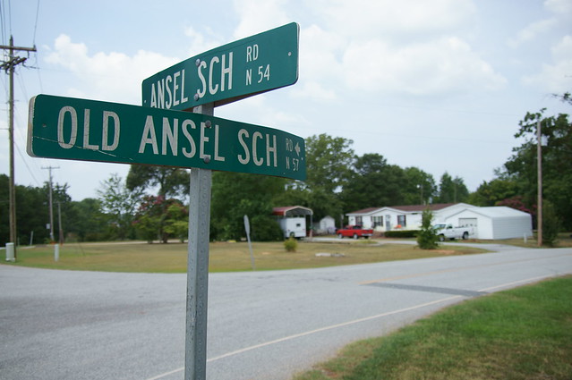
According to the deed in book 230, page 492, the property was sold off to the highest bidder at auction on January 27, 1951 to an M. A. Mason. The property would later be divided into two lots, and the names of the roads passing by and near the school property would be altered. Tracing the subsequent owners of the land forward in time shows that the location of the school was near the intersection of Ansel School Road, what is now Old Ansel School Road, and what is now Holiday Road:
A deed recorded October 13, 1896 in deed book EEE, page 324 transfers one acre of land from S. D. Mosteller to Ansel School District "only for school purposes for educating white children" and also grants the school use of a well in the northeast end of the property. On September 26, 1919, the school district added more land to the school property by buying another acre from S. D. Mosteller.
According to the deed in book 230, page 492, the property was sold off to the highest bidder at auction on January 27, 1951 to an M. A. Mason. The property would later be divided into two lots, and the names of the roads passing by and near the school property would be altered. Tracing the subsequent owners of the land forward in time shows that the location of the school was near the intersection of Ansel School Road, what is now Old Ansel School Road, and what is now Holiday Road:
If you'd like to know where some other Greenville County schools that no longer exist were located, please leave a comment. The research isn't that hard thanks to the indexes provided by the Greenville County Register of Deeds site (just look under the indexes for "school"), but it is tedious.
Update: With historical South Carolina Department of Transportation maps now online, locating schools with time consuming property research isn't really necessary anymore.


Most of these school names are available in the USGS Geonames Database, also known as GNIS. These are available from http://geonames.usgs.gov . However, I've created a subset of this list specific to South Carolina at http://www.randomconnections.com/scplacenames . You can search for any place name.
ReplyDeleteIn the case of Ansel School, GNIS has (Historical) next to the name because it no longer exists. According to the lat/long coordinators in GNIS, here is a map of the location:
http://maps.google.com/?q=34.9656715,%20-82.252613
Hmmm...looks like the GNIS places the school one street west of where I place it. Time permitting, I'll add the GNIS location a link to a plat survey showing the location.
ReplyDeleteThanks for the links! I had already came across about a week ago the KMLs you produced in a blog post of yours about old rural schools. I was using them to try to find the location of an abandoned school building I found on flickr. None of the buildings matched the photo so no joy.