Photographic explorations centered around Upstate South Carolina.
A Visit to Beech Bottom Falls and Sassafras Mountain Overlook Tower
Get link
Facebook
X
Pinterest
Email
Other Apps
Soon I'll be leading a hike up to the observation tower on Sassafras Mountain on the Foothills Trail (weather permitting of course!). I haven't hiked this section of the Foothills Trail before, and I wanted to see what it's like on my own before I lead the group hike. I also wanted to see Beech Bottom Falls, formerly known as Pinnacle Falls, while I was there. That waterfall is down a different trail I had visited in 2015. A new trail was opened in the summer of 2018, the waterfall renamed at the same time, and the old trail has been abandoned.
I parked at the Chimneytop Gap parking access area, off U.S. 178 seven miles north of the intersection with S.C. 11. I thought too many cars were parked here to all be individual hikers. I figured it had to be some sort of a meetup.
I also figured they were probably headed up Sassafras Mountain. But for now, I'm more interested in what's down Beech Bottom Falls Trail.
Beech Bottom Falls Trail
The bat roost I saw in 2015 is still there:
During construction of the trail, a wood bridge was installed over Abner Creek.
In 2015, I had to ford the creek. Back then, there was no signage on the old trail. The new trail is well signed though.
A second wood bridge, looking very much like the first, spans a different section of Abner Creek.
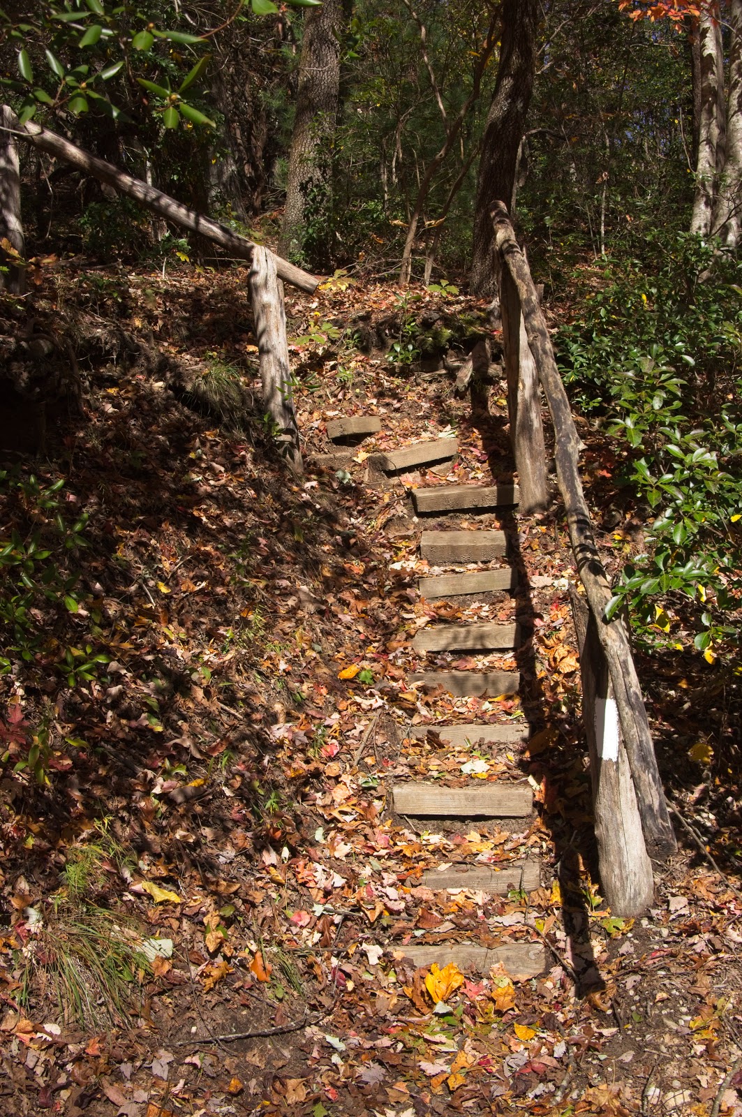
A sign a half mile from the observation deck warns hikers to stay on the trail.
The observation deck is down a steep set of stairs overlooking Beech Bottom Falls and Abner Creek.
Down below, I could just make out another but much older observation deck. This one belongs to Camp Hannon.
Until the summer of 2018 when the new trail was opened, Beech Bottom Falls was known as Pinnacle Falls. I have no idea why the name was changed. Whatever your preferred name is for this waterfall, Beech Bottom Falls is quite beautiful. Recent rains have perked up the water flow a good bit.
I took a short video with my cell phone to show the water flow:
Foothills Trail to Sassafras Mountain
I made my way back to the parking area, then walked down a few hundred feet down U.S. 178 to start up Foothills Trail to Sassafras Mountain.
This section is the steepest of the three segments up the mountain.. I met some people coming down the trail. My suspicions of a meetup proved correct. A hiking group had indeed hiked up the mountain and were now coming back down.
What started out as a single track width trail soon widened to road width as the trail joined with an old logging road. Foothills Trail joins and leaves old logging roads at least twice that I noticed. The middle segment follows another old logging road, where this sign is located:
This part of Foothills Trail parts ways with the old logging road as the trail ascends to F. Van Clayton Memorial Highway.
This small parking area is where the third and final segment begins for the final ascent up Sassafras Mountain.
I watched a steady stream of traffic head tower the top of mountain before I could finally cross over the road and up the stairs.
This section was a steep at times, but not as strenuous as the first segment. I didn't see anybody until I got to this sign:
Then I could see all the people that had come up the road the easy way. Some had setup a picnic on a flat rock, but most others will milling around taking photos of each other and taking selfies. The observation tower was quote popular.
I searched for a bricked area for a particular Meetup I'm a member of:
I took photos of the observation tower itself and the compass on top of the tower:
I also took photos of the black stripe that marks the border between North and South Carolina.
And of course I took photos here too. How could one not?
I also took some panoramas from a few different views:
As soon as I got back on Foothills Trail, the crowds quickly disappeared behind me. The downhill hike back to my car went by rather fast. That meetup group had gone home long before I made it back, leaving my car the only one left when I reached the parking area.
This hike had enough strenuous parts to exercise the legs, but not so strenuous that it becomes grueling. I hope my group will like it.
With September comes meteorological fall and cooler weather, and the area experienced just that for a few days around last Sunday. My original plan last Sunday was to spend time with my ailing 14 yr old cat, Princess, but she didn't even make it past Monday. I changed my Sunday plan to a day trip and, after consulting my ever growing to-visit list, I settled on a paddling tour of Lake Summit in Tuxedo, North Carolina. I arrived there early, at least by my standards. The place wasn't very busy when I arrived. Permits are required to access Lake Summit for powered boats and personal watercraft like jet skis, but no permit is required for kayaks. Works out fine for me! However, to get a permit you must live in the Green River Fire District. The website of the homeowner's association has those details. The gate for the boat ramp was closed at the time, forcing me to walk through the pedestrian access with my inflatable kayak. I launched and headed for my first plann...
After reading a goupstate.com story on the destruction of the old Lyman Mill in Lyman, SC that closed in 2005, I quickly decided I wanted photos of the mill before they get too far along tearing down the mill. View Larger Map I thought being a Sunday the crews wouldn't be working, but I was quickly proved wrong. A few people were in their machines busy with their work. The area is surrounded by a construction fence, but a large part of the parking lot is still available to park and walk around. Part of the work is already done, and the company performing the destruction expects to done by the end of May. Most of the mill is still intact at this time. If you want to visit though, you better visit soon. I also found an abandoned railroad right of way I just had to explore. I traced it back to where it headed into someone's property, and not far beyond it presumably would have merged with the mainline. Then I traced the line toward the mill....
After seeing the abandoned railroad right-of-ways at Shoals Junction and nearby communities, I wanted to know more about the abandoned railroads of South Carolina and what traces could still be seen today. I found part of my answer in the South Carolina section of Abandoned Rails , a website devoted exclusively to abandoned railroads and their history. I was fascinated by the site's individual maps of abandoned railroads because the satellite view shows the right-of-way is still visible in many cases, even after decades of abandonment. Some time later, I came across the South Carolina Department of Transportation's draft multimodal transportation plan and rail inventory that included a map of the state's abandoned railroads on page 13 . With the map being a static image, you can't zoom in or change views to get more detail like the Abandoned Rails maps that use Google Maps. With the heat and humidity keeping me indoors as often as I can get away with, I d...


Comments
Post a Comment